|
RECENT ACTIVE VOLCANOES
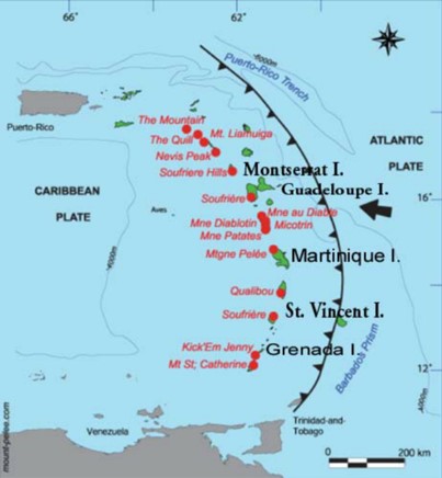
Sixteen Holocene volcanoes are located in the Lesser Antilles, from the southernmost island of
Grenada to the northern island of Saba, of the Dutch Antilles. Of these, nearly 90% are andesitic
stratovolcanoes.
Activity here is dominantly explosive with most eruptions recorded with explosive elements.
Whereas the most common eruption size in most regions is VEI 2, here nearly half of all eruptions
with a given size have been VEI 4. Nearly 70% of the volcanoes have Holocene records of producing
pyroclastic flows, and about three quarters of all recorded eruptions here produced pyroclastic
flows. Pyroclastic flows are recorded in about half of all historical eruptions, whilst only 2% of historical events have recorded lava flows. About a third of historical eruptions have resulted in lahars. Four historical eruptions have generated tsunamis.
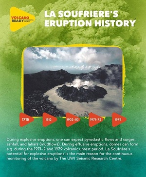
Soufriere de St Vincent
The Soufriere volcano is a 1220 m high stratovolcano which occupies the northern part of the island of St. Vincent. It is one of the most active centres of volcanism in the Caribbean and has a record of activity dating back to the Pleistocene. This stratovolcano has developed as a result of the subduction of the Atlantic Ocean crust beneath the Caribbean Plate. Twenty-one Holocene eruptions are confirmed at Soufrière St. Vincent, between 2380 BC and 1979 AD. These eruptions have varied in size from VEI 0 to 4, however all eruptions prior to the 1700s are of unknown magnitude. These eruptions however, all have records of producing explosive products including pyroclastic flows. Petrochemical work has shown that magmas involved in the explosive eruptions were quite narrow in compositional range, mainly comprising basaltic andesites. The 1902–03 eruption involved a late stage basaltic component in March 1903. However, activity in the last 1000 years generated notably more homogeneous magmas with a narrower range than the older eruptive periods previously reported in the literature, suggesting a significant variation in the magmatic reservoir feeding system with time.
Historic eruptions (since 1718) have caused over 1600 deaths and resulted in damage to property valued in excess of 4.8 million USD. In addition, current development plans for the area point towards increased risk of disastrous consequences from future activity at the volcano. The experience of the 1902, 1971 and 1979 eruptions of the volcano demonstrated that the entire Vincentian society can be affected in some measure by volcanic activity. The most direct effects were felt by people occupying the zones of greatest hazard. They incurred the greatest losses, and were displaced by the events. During the 1979 eruption, 20 000 people were evacuated from all areas north of a line extending from Spring Village in the west to Colonaire in the east. Robertson (2005) described eruption scenarios at Soufrière St. Vincent and presents integrated hazard maps for effusive dome-forming and explosive eruptions, showing much of the north of the island as Very High Hazard, with decreasing hazard moving southwards. Being
only a small island, the whole of St. Vincent lies within a short distance of this volcano, and the 100
km radius of this volcano extends to nearly fully encompass the islands of the Grenadines. This
radius also extends to fully encompass and expose St. Lucia, and indeed, the 100 km radius of the
Qualibou volcano on St. Lucia extends to encompass the whole of St. Vincent. All infrastructure is
exposed here.
Montagne Pelée ( Martinique)
Montagne Pelée (1394 m), forming the northern end of the island of Martinique, is the most active volcano of the Lesser Antilles arc. Historical eruptions date back to the 18th century; only two modest phreatic or phreatomagmatic eruptions took place prior to 1902. Five historical eruptions are recorded at Montagne Pelée.
These eruptions have ranged in size from VEI 1 to 4. The largest historical eruption was that of
Montagne Pelée in 1902. This catastrophic VEI 4 eruption produced pyroclastic flows and destroyed
the city of St. Pierre, resulting in nearly 30,000 fatalities became the type-example of pelean eruptions and marked the onset of modern volcanological studies of the behavior of pyroclastic flows.
Being small islands, relatively high proportions of the population live within 10 km of the volcanoes
here, with about 5% of the population of Martinique living
within this distance. The whole population lives within 100 km of these volcanic centres.
Boudon et al. (2005) present possible future eruption scenarios for Martinique and suggest that the
most probable activity is phreatic events, dome-forming eruptions or open-vent pumiceous
eruptions. They also suggest that collapse of the south-western flank of the volcano is of low
probability, but consider it due to the devastating effects it could have, including potential for
directed blasts and tsunami generation. They present a hazard map for Martinique based on a
quantitative assessment of volcanic hazard, showing hazard concentrated around Montagne Pelée
and St. Pierre, with much of the southern half of the island being of low hazard. Pelée is monitored by the Observatoire Volcanologique et
Sismologique de
Martinique (OVSM/IPGP). Extensive seismic, deformation and geochemical networks
are in place at volcano.
Soufriere Guadeloupe
Eight eruptions occurred at the Soufriere during historic time. Latest phreatic activity occurred in 1975-76. As of the Martinique, relatively high proportions of the population live within 10km of the volcano. On the Guadeloupe island about 17% of the population living within this distance. Komorowski et al., (2005) suggest future eruption scenarios for Guadeloupe in order of decreasing
probability of occurrence of: intense prolonged fumarolic activity, phreatic eruptions, edifice
collapse eruptions, effusive and explosive dome-forming eruptions and large explosive eruptions.
They present an integrated hazard map for these scenarios with the area of highest hazard being
located around the summit of La Soufrière of Guadeloupe and to the south-west, with additional
high hazard in the valleys radiating from the volcano. The volcano is monitored by the Observatory volcanologique and sismologique de Guadeloupe (OVSG/IPGP)
Soufriere de Monserrat
The Soufriere Hills volcano is situated to the south of central Montserrat. Being a small island, all
infrastructure and population here lies within 20 km of the volcano. Indeed the 100 km radius of Soufriere Hills extends to encompass much of Guadeloupe, St. Kitts and Nevis and Antigua and
Barbuda, exposing much of the infrastructure here. Soufrière Hills volcano is currently active. Historic activity in the 17 th Century produced the Castle
Peak lava dome and seismic activity has occurred in swarms at 30 year intervals in the 20 th Century.
No other eruptions are recorded until the ongoing eruptions which started in August 1995. Eruptive
activity is typified by lava dome growth followed by collapse resulting in pyroclastic density currents,
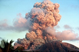
lahars and ash plumes. Parts of the southern half of the island were evacuated in 1995. In June 1997, 19 people were killed
by pyroclastic density currents resulting from partial dome collapse. By 1998, approximately 70% of the population had left the island (Kokelaar, 2002). The capital city
of Plymouth has been destroyed by multiple ash fall and pyroclastic density current deposits. Montserrat has a dedicated volcano observatory: Montserrat Volcano Observatory (MVO) run by the
University of the West Indies Seismic Research Centre.
Dominica Islands
The 5 volcanoes in Dominica form a chain across the island. Two volcanoes
have no confirmed Holocene activity on record. Morne Trois Pitons, Morne Plat Pays and Morne
Watt have a Holocene eruption record, including historical activity at the latter. Unrest has been
described at Morne aux Diables and Morne Trois Pitons since 1900 AD.
Being only a small island, measuring no
more than 50 km across the country in its entirety lies within a short distance from Holocene
volcanoes. Indeed the 100 km radius of the Dominican volcanoes extends beyond Dominica to
encompass Guadeloupe and much of Martinique, exposing much of the critical infrastructure on
these islands. The whole population of the island resides within 30 km of one or more
Holocene volcanoes. Indeed, about 84% of the population live within 10 km. The highest proximal
population is at Morne Plat Pays, where several towns lie in the valleys radiating from the volcano
and the capital, Roseau, lies within 10 km.
|

Carte des Risques - Montagne Pelée
Soufriere Hills eruption 1997 -(H.Gaudru)
|